
Melanesia, 1774. The famous captain James Cook drew a large island of sand on a map covering the current area of New Caledonia. The captain named the island Sandy, a sign of its ingenuity and originality. This island was reproduced in maps until the year 2000. Until the cookies proved that there was no more than water in the place drawn. Is it possible that the alleged amount of sand discovered by the explorer has been submerged over the centuries? No, because in that area the ocean is about 1,400 meters deep.
The fact is that at one time the French claimed, and succeeded, the rights on the part of land that does not exist. Since then, this empty water area is called Ile de Sable.
An English whale, Captain Dougherty, reported in 1841 that he had found a small island near Australia. In all humility he called him the island of Dougherty. In the original description the captain said the alleged land was covered in snow, but a 1909 expedition was unable to find the island. Years later, a fellow man from Cook and Dougherty, Captain Davis, wrote: “I have the impression that the island of Dougherty has collapsed.” There wasn't the island either, but in this case the fishing whale didn't get right what it had seen, but found an iceberg.
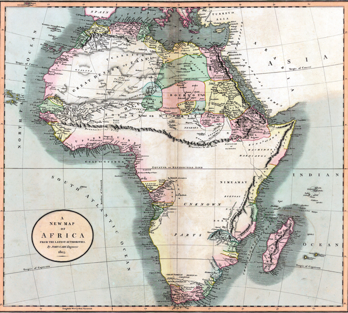
In 1798, the cartographer James Rennel, based on the information provided by the Scottish explorer Mungo Park, drew on a map of central Africa a chain of thousands of kilometres: Kong Mountains. A gigantic mountain range would pass through, among others, the present Nigeria and Sierra Leone.
Rennel, the founder of the Royal Geographical Society of London, did not doubt what he had drawn and, for a hundred years, travelers gave a long rodeo to avoid the abrupt orography. Of course, when Frenchman Luis Gustave Binger decided to explore the mountain range on purpose, he found nothing. So in the late 19th century, the mountains of Kong began to be removed from the maps.