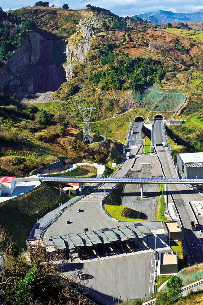
Gezurra dirudi porlana nagusi den hain inguru handian Bolintxu moduko berdegune natural batek bizirauteak. Zoritxarrez, laburrerako izan daiteke Bizkaiko Foru Aldundiak Supersur errepidea luzatzeari ekiten badio. Momentuz ez da eperik zehaztu, baina proiektua onartuta dago. Noiz arte eutsiko dio Bolintxuko haranak paradisu natural izateari?

Metropoliaren Hegoaldeko Saihesbidea, edo nahi izatera, Supersur, A-8 eta A-68 errepideen arteko karreju “naturala” da. Lehenengo fasea amaituta, errepidearen hamazazpi kilometro daude erabilgarri 2011ko irailetik, Santurtziraino heltzen direnak. Bigarren fasea, Bilboko Peñascal eta Arrigorriagako Beteluri auzoak lotuko dituena (3,4 kilometro), egin barik dago. Oraingoz, beraz, aukera badaukagu Bolintxu haranaz gozatzeko. Bilboko Metropoliaren inguruetako leku enblematikoa da Bolintxu, baita Bizkaiko Foru Aldundiarentzat ere. Horrela jasota dator behintzat Metropoliaren Hegoaldeko Saihesbideko 9. tartearen (Peñascal-Beteluri) Trazadura egiteko proiektuaren Ingurumen Eraginaren Adierazpenean.
Naturgune aberatsa
Saihesbidearen bigarren zatiak Bilbo eta Arrigorriaga elkartuko lituzke, A-68 autobidearekin lotura zuzena lortzeko. Lanek hasiera izango lukete Arnotegi mendian eta amaiera, aldiz, Seberetxe, Buiagoiti eta Beteluri auzoetan. Tartean, Pagasarri mendiaren oinetan, Bolintxuko troka sakona ukituko lukete, “esangura bereziko ingurunea, naturaren eta paisaiaren aldetik dituen balioei dagokienez”.
Bolintxu haranaren zati handi bat haritzek hartzen dute, errekaren bueltan Europar Batasunaren lehentasuneko intereseko habitata osatzen duten haltzadiak daude eta Bolintxuko harrobi abandonatuan hegazti harrapariak ugaltzen dira. Mendi taldeek txangoak antolatzen dituztenean ere baimena eskatu behar izaten dute, ugalketa prozesu horri ez eragiteko. Pasealeku ederra bakarrik ez, paradisu txiki hau oasia ere bada hein handi batean. Bolintxu errekako urak igel, suge eta anfibio askoren bizileku ere badira; tartean, babestu beharreko espezie birena, 2010ean Gorka Belamendiak egindako ikerketan jasoak: iberiar igela edo hankaluzea, eta Coronella austriarra edo suge liso europarra. Are gehiago: narrasti eta anfibioetan Gorbeiako parke naturalaren kopuruetan dago Bolintxu, kontuan hartuta bataren eta bestearen tamaina –Bolintxu baino 200 aldiz handiagoa da Gorbeia–.
Hori guztia jakinda, ez da oso ondo ulertzen Supersur errepidearen proiektuaren ibilbidea bertatik egin nahi izatea. Askok azaldu dute horri buruzko kezka. Proiektuaren Ingurumen Eraginaren Azterlanak berak ere 31 eragin identifikatu zituen errepidearen bigarren fasean, eta horietatik hamaika jotzen ditu larritzat: azaleko ur masak jasango lukeenaz gainera, lehentasunezko intereseko habitatak eta intereseko florak ere jasango lituzkete eragin larriak, paisaiari egindakoaz gain. Bolintxu haranean ez ezik, Arnotegi mendiaren ekialdeko hegalean eta Seberetxeko auzoaren inguruetan ere kalte larriak identifikatzen ditu ingurumen txostenak. Printzipioz proiektuak zuzenean eragingo ez dion arren, ustezko arkeologia gunea ere badagoela gogoratzen du: Arnotegiko iturria.
Pagasarritik Bolintxurainoko jaitsiera
Bilbotik hain gertu dauden paraje horiez guztiez gozatzeko proposamena duzue testu hau, 1.730 metro luze diren tunel bikoitzek eta 166 metroko biaduktoak argazki zoragarria suntsitu aurretik. Bolintxu errekak ematen dio izena inguruosoari. Bilboko sarrera guztietan gertatzen den legez, bertara heltzeko ere jaitsi beharra dago, bai Abusu auzotik, bai Pagasarriren bidetik.
Peñascal auzotik oinez ordu erdira dago Bolintxuko harana, Pagasarri eta Arnotegi mendien magalean. Aukeran, badago Ganekogorta kateko mendi ezagunenera igotzeko bidexkatik heltzea. Esango nuke Pagasarrizale (671 metro) gehienek bide horixe erabiltzen dutela. Guk bisita egin dugun egunean, Arnotegira irteera egin duten guraso eta neskato-mutiko koadrila handi bat topatu dugu, bai eta ere Abusuko auzokideak iganderoko txangoa egiten. Haiek azaldu digute ingurunea udaberrian dagoela ederren, natura bizi-bizi dagoen sasoian, zuhaitz guztiak loretan. Zoritxarrez, guri egun euritsuak tokatu zaizkigu, eta erreka bazterretik ez abiatzeko gomendioa egin digute, lupetzaz beterik baitago.
Hala ere, egin dugu ostera, zortzi kilometroko ibilbide zirkularra. Abusu auzotik hasi ordez, Igertuko aparkalekutik abiatu gara, Pagasarrira bidean dagoen azkeneko parkingetik. Ezkerretara Arnotegira doan bidea dago, eskuinera berriz Pagasarrira igotzen dena. Guk, aldiz, parkingaren barrenetik beherantz egiten duen bidea hartu eta Bolintxu errekaren ertzeraino jaitsi gara.
Araztegiko hodia da bidea
Garai bateko Bilboren hazkundeak ez zion eragin Bolintxuri, bai ordea ur araztegiak. 60ko hamarkadaren amaiera aldera jarri zuten harana zeharkatzen duen hodi erraldoia. Handik ekartzen zuten Zadorrako urabilbotarrei edaten emateko. Aurretik, 1923an, beste araztegi bat egon zen inguruan, eta kendu zutenean igerileku ere izan omen ziren presak. Baina 1983ko uriolek desegin egin zituzten eta gaur egun, harri-horma zati bat baino ez dago ikusgai, jausia eragiten duena uraren ibilbidean. Egunotan ikusgarria da ur-jausia. Erreka ondotik dakargun bidexkakharaino heltzeko aukera emango digu, bai goiko partean bai behekoan ere. Merezi du hurbiltzea errekaren ibilbidea zuzen-zuzen ikusteko eta hango zuhaitzen tamainaz ohartzeko.
Bolintxu errekaren ertzetik ibiltzea, ur kanalizazioaren hodiaren gainetik joatea da. Tarteka, gainera, agerian geratu dira iraganean hondatutako hodiak; beste batzuetan hodia zapaldu beharko dugu, huraxe baita bidexka.
Ikusgarria da, halaber, haran osoa zeharkatzen duen Ur Partzuergoaren hodi erraldoia. Gure ibilbideak hodiari eusten dion biadukturaino eramango gaitu, eta azpitik zeharkatu beharko dugu. Atsedenleku aparta suerta daiteke uda partean, errekaren freskotasunaz gozatu eta mokadutxoa bertan hartzeko.
Abrari begirako igoera
Erreka ondotik egin dugu Bolintxu auzoraino bidea, baina bueltakoa guztiz bestelakoa izango da. Behin errepidera ailegatuta, beti ere errekaren ondo-ondotik, ezkerretan dagoen aparkaleku batera joko dugu. Bideari jarraituz Abusura iritsiko ginateke, baina ibilbidearen beste erdia egin nahi dugunez, aparkaleku txiki horretan gorantz doan bidea hartuko dugu. Aparkalekuaren gainean sasoi batean uren estazioa izan zen eraikin erraldoia ikusiko dugu, jauregi itxurako etxe grisa.
Datorrena nahiko bide malkartsua da; kontuan hartu lehen jaitsi dugun guztia igo behar dugula bueltako bidean. Beraz, lasai hartu. Erdibidean, burdinazko ate erraldoia zeharkatutakoan, askaldegi bat aurkituko dugu, baina merezi du segitzea eta Eguzkialde izeneko parajeraino iristea. Han beste askaldegi erraldoi bat dago, Bilboren ikuspegi zoragarria eskaintzen duena. Eskuineko aldean Abra ere ikus daiteke.
Indarrak berreskuratuta ezkerretik doan bideari segituko diogu, oraingoan bai, zuhaitzez inguratuta –aurretik igo dugun tarte guztian ez dugu zuhaitz bakar bat aurkituko; hortaz, uda partean, adi–. Ezkerreko bidean aurrera eginda azkeneko askaldegira iritsiko gara, Elordira; han bertatik Arnotegira igotzeko aukera ere badago, baina gure helburua Igertuko aparkalekura itzultzea denez beheranzko bideari ekingo diogu. Ordu laurdenean iritsiko gara parkingera.
Behin Igertura iritsita, ez ahaztu, Bilbora eramango gaituen Larraskitu bidera iritsi aurretik, ezkerrera begiratzea azkenekoz. Hantxe aurkituko dugu berriro Abrarainoko ikuspegi zoragarria, baita dagoeneko eginda dagoen Supersurraren lehenengo zatia ere. Hiruna erraileko autobidea, bere zortzi ordainlekuekin. Harrobi zaharraren ondoan irekitako begi handi beltzek zaintzen dute gertu-gertutik Pagasarri bidea, baina izan daiteke, zaintzen barik, mehatxatzen egotea, han hiltzen den errepideak bere bidea egitea erabakitzen badu.