Los Angeles, one of the largest cities in the United States. United States And from the world, it's been buried by the terrible fires that have forced 150,000 people to move. The mayor has declared a state of emergency, hundreds of homes have been burned by flames in different neighborhoods and strong winds have not left any trace of mint for the time being. There is also an untenable urbanism that has been subtracting to the mountains an extension of several kilometres.
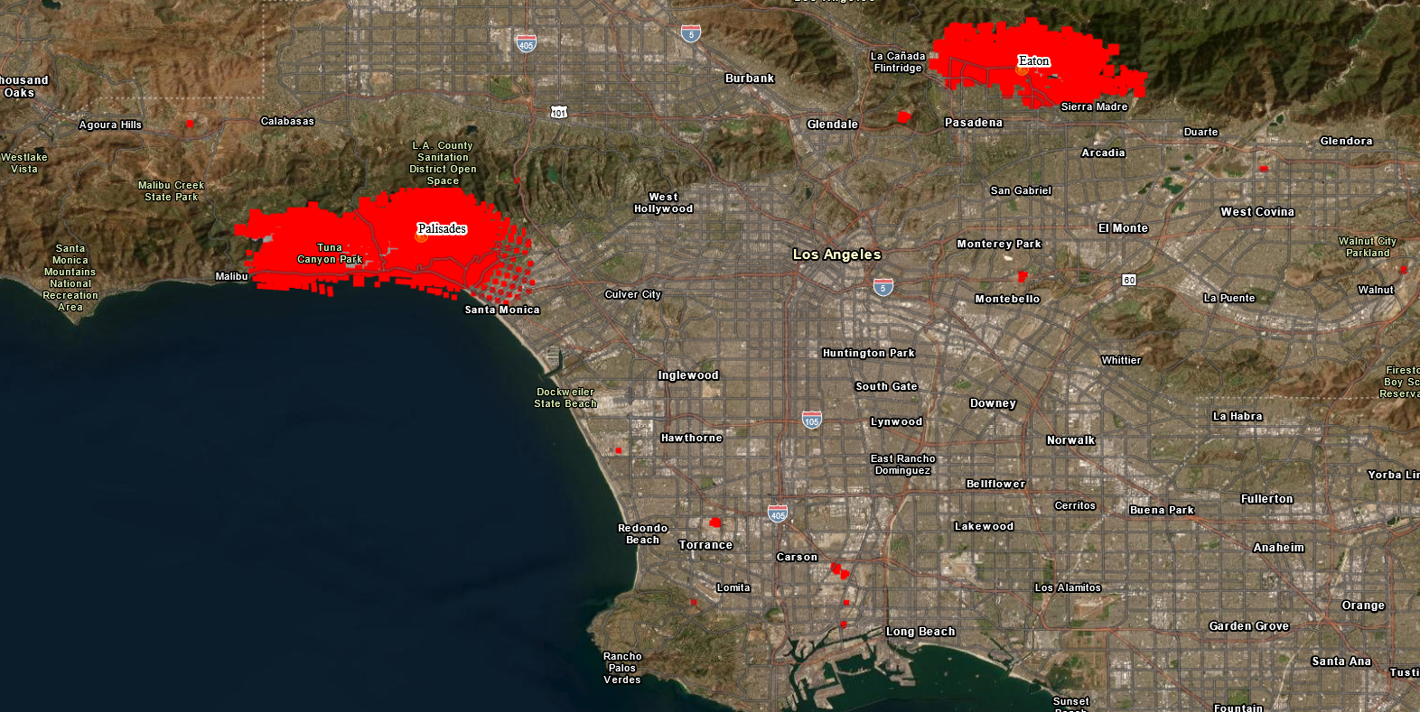
The city of Los Angeles, in California, is surrounded by large fires, which have already ravaged over 11,000 hectares, including forests and mountains, but also entire neighborhoods, among other places. Thus, according to the latest data offered by US television networks, more than 1,000 buildings have become ashes and another 15,000 are exposed to the same dangers.
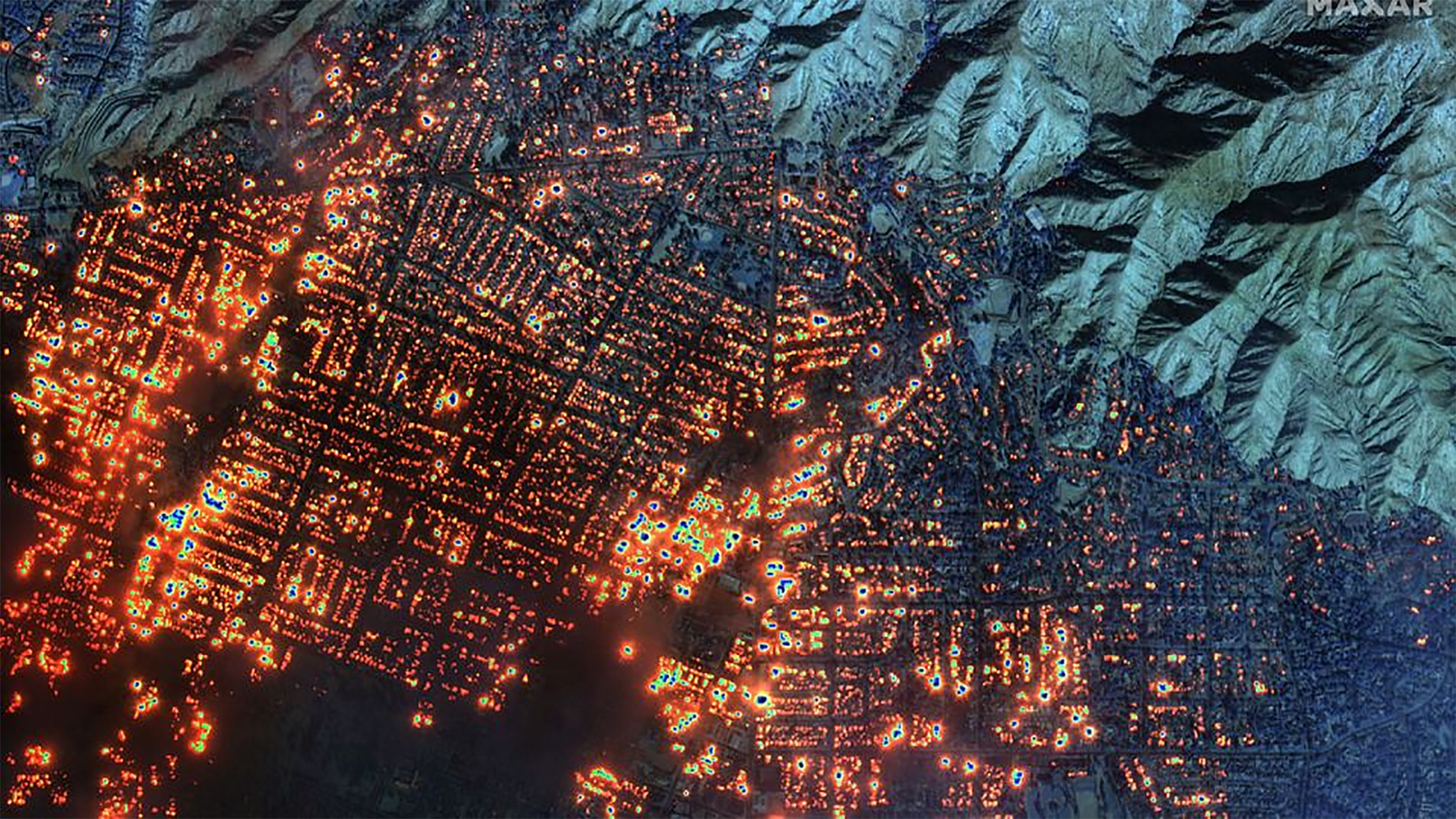
Los Angeles Mayor Karen Bass has declared a state of emergency and 150,000 people are already displaced to the area. Organizers have stressed that the city suffers from the largest fires that have been recorded "in modern history". The situation has been complicated by the action of the wind, which at a speed of 160 km per hour has taken the form of a "hurricane of fire". It has been recognized that there may be a large number of injuries and at least five people have died in the accident.
The fire map installed by NASA and the U.S. Forest Service clearly shows the characteristics of the fire. Although there have been larger fires, such as in the Brazilian state of São Paulo, where last year 370,000 hectares of tropical forests were burned and throughout the country, the flames of Los Angeles have occupied bright avenues, luxury neighborhoods and urban centers, leaving spectacular images.
Among the affected neighborhoods are emblematic places such as Hollywood or Malibu, among others. In particular, there are two fires that have caused the greatest damage, one on the coast, in the northeast of the city, called Palisades, whose mountains are named after the famous beaches of Malibu. The other is located near Los Angeles National Forest Natural Park, called Eaton.
The dry winds caused by the climate madness and the powerlessness that the US public administration has often shown in dealing with this type of disaster may, in part, explain what happened. But it's also about taking the American Dream to the extreme in Los Angeles.
The rich neighborhoods climb the mountain and the city's arms extend without limits, like extensive domestication. This has more than one risk, including fire-fighting.
In all these areas, the neighborhoods of the rich climb the mountain and the city's arms extend without limits, like an extensive plantation. This has more than one risk, including ending the fires so frequent in the Mediterranean climate of California.
The problem is not today.
Already in 2007, Pello Zubiria warned us of the phenomenon in the Net Gertu section, in a report on Pindar bat Malibu, to destroy all its charm. Taking as a source the well-known Californian historian and sociologist Mike Davis, Zubiria explained that in these areas the original vegetation is chaparral or charady and that, due to different factors, every decade there is a colossal fire with this fuel.
If in the past Los Angeles was not a megalopolis, but the dwelling of the original peoples of the coast, these fires made the land a revitalization function. Now, the damage to "modernity" is evident in a deadly cocktail caused by global warming, dryers, plant diseases and other factors.