- Throughout the twentieth century, the expansion of forests has been to the detriment of grasses and agricultural lands. This transformation of the Basque landscape has been more notable on the Cantabrian side. It is in this aspect that the greatest presence of forest soils of low integrality with the ecosystem is concentrated.

In 1900, grasses and forests accounted for 42 per cent (8,800 km2) and 36 per cent (7,500 km2) of the Basque Country ' s area, respectively. In 110 years they have grown from about 2,000 km2 of forests to grasslands, and already account for one third of the Basque Country’s area (6,900 km2). Forests account for 44 per cent of their area (9,300 km2). Although the land area currently devoted to agriculture is similar to that of the early twentieth century, in the post-war decades (1950/1990) the area devoted to this activity is less than that devoted to it. In fact, some 600 square kilometres of land devoted to agriculture in that period - about 2.7% of the area of the Basque Country - currently corresponds to a different activity.
These are the results of research carried out for the whole of Europe by the University of Wageningen (Netherlands). It offers the possibility of analyzing the use of Earth from the perspective of historical evolution, based on the HILDA methodology The Historic Land Dynamics Assessment. To this end, digital techniques, national inventories, aerial photographs, terrestrial coverage statistics, the old encyclopedia and historical terrestrial coverage maps data have been combined and combined. The result has a precision of one square kilometre, that is, the type of land that predominates in one square kilometre is attributed to the entire square kilometre. There are sources that offer more detailed data for the entire Basque Country, such as the European Corine Land Cover project. However, the work of Wageningen University is pioneering in offering a perspective of historical evolution.
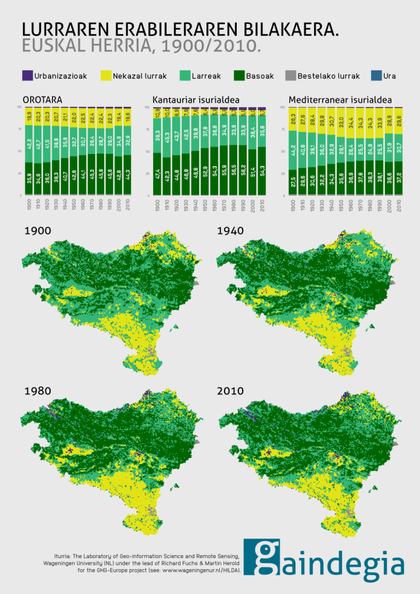
Extension of forests on the Cantabrian side to the detriment of grassland and agricultural land
In the Basque Country there are two sides: the Cantabrian side in the north and the Mediterranean in the south. From the climatic and orographic point of view, they are differentiated realities. Forests on the Cantabrian side account for just over half of the total area (54 per cent). In the Mediterranean area, the presence of forests is limited to 37%. On the contrary, the presence of agricultural land is significant in the south, reaching 30% of the surface area. In the wet and mountainous north, agricultural land accounts for only 6 per cent of the area, and so its conservation is so important.
In addition to climatology and orography, current land use is a consequence of various historical processes. The economic growth of the twentieth century increased the demand for wood and generated the expansion of forests, especially on the Cantabrian side. The greater extent of public or communal property on the south side, among other factors, gave rise to a different evolution. Currently, 76.2% of the Álava forest area remains in the public domain, far from the reality of Bizkaia and Gipuzkoa. As for the latest data from 2016, only 23.7% and 21.2% of the forest area of these countries are public soils.
On the Mediterranean side, the extensive expansion of agricultural land in the twentieth century stands out, until in the 1960s the late industrialization first and the subsequent loss of activity of the primary sector after the European Common Agricultural Policy. In this process, agricultural land was reduced and pasture spread. Closer to time, the growth of urbanism has also caused in the last three decades a reduction of agricultural lands, which lead to urbanism the plain and plough terrain of urban centers. The impact of this transformation is more significant in the Cantabrian side, since the highest degree of artificialization in the period 1990/2018 has occurred in the counties where the soil considered suitable for agriculture is scarce.
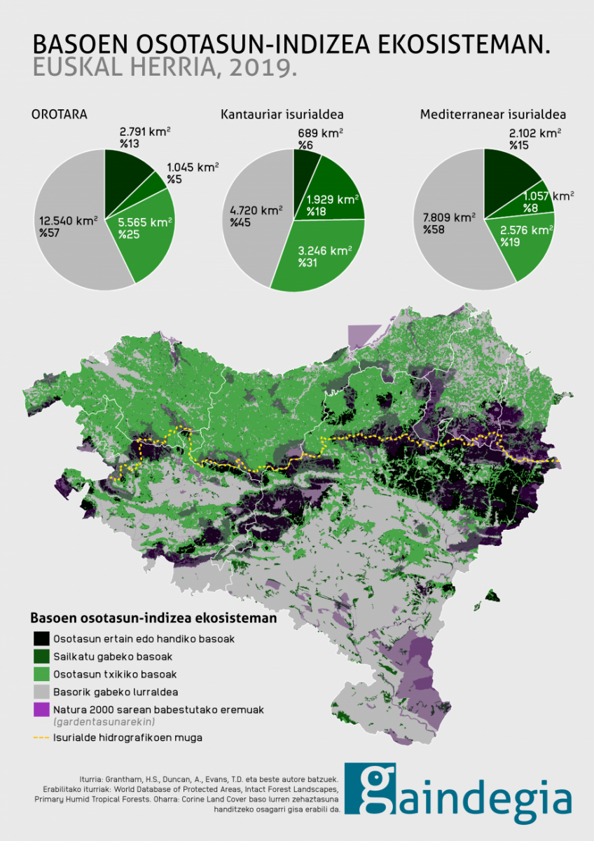
Two-thirds of our forests are considered to be poorly integrated with the ecosystem, particularly on the Cantabrian side.
Deforestation is a major environmental problem in the world, but the anthropogenic transformations of forests also affect the integrity of ecosystems. So, Grantham, H.S. Duncan, A. Evans T.D. Other authors, using Google Earth Engine (GEE), have created the Forest Landscape Integrity Index. This index describes the integrity of forests from 2019 onwards, taking into account local anthropogenic changes. This methodology is also the result of the integration of variables such as the extension of forests, high-impact human activities (infrastructure, agriculture and deforestation), the loss of connectivity of forests and the pressure of other activities, among others.
This methodology has been widely recognized by the international scientific community and, by differentiating three levels of integrity, has completed a photograph of the state of forests around the world. The classification of forests is made in three categories: low, medium and high integrity. In any case, this is a methodology aimed at measuring large territorial areas by issues of scale, rather than details of sinuous orographic territories and surface areas such as that of the Basque Country. Thus, in the Basque Country, forests with a high degree of ecosystem integrity have not been identified, although they do exist. Compared to other areas of the world, the extent of the forests of the Basque Country is small and the anthropized areas are not so far from the essence of the forests. This also influences the connectivity of forests.
Despite these limitations on results, research results indicate that two-thirds of Basque forests (66.6%) have a low level of ecosystem integrity (5,565 km2). This figure is significantly higher on the Cantabrian side (82.5 per cent) than on the Mediterranean side (55.1 per cent), as well as on its gross surface: on the Cantabrian side, low-integrity forest lands occupy an area of 3,246 km2. On the Mediterranean side, these forests have an area of 2,576 km2.
The European Commission has recently expressed its intention to support biodiversity and landscape identity in the design of the new Common Agricultural Policy (2021-2027). It aims to integrate agriculture into the strategy to combat climate change, as well as the responsibility to ensure food security. It will therefore be important to ensure the use of agricultural land. It will also be necessary to combine and balance wood production with ecosystem conservation and biodiversity. These are challenges to be understood at a time when the strategic importance of local production capacity is beginning to be recognized. For this reason, undeveloped lands require management based on sustainable models, even more so in a territory as small as the Basque Country.